


EARS Earth Environment Monitoring contracted to develop flow monitoring system for Niger River
 Remote sensing company EARS Earth Environment Monitoring has been contracted by the Niger Basin Authority (NBA) to develop and implement a water monitoring and flow forecasting system for the Niger River, based on data from geostationary meteorological satellites (meteosat).
The project is carried out in cooperation with the Unesco-IHE Institute for water education. The project runs almost 4 years and is followed by an operation and maintenance phase of 5 years.
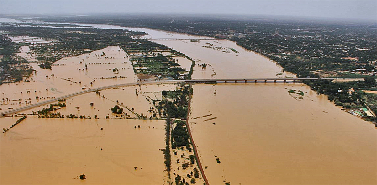
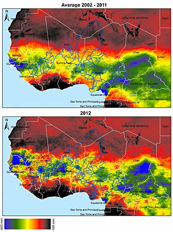 Months of heavy rains, especially in Mali (blue left middle) and Chad (blue right), flooded the Niger river in 2012. Niger's capital Niamey (top photo) was hit when the river burst its banks.
Own developed EWBMS-system
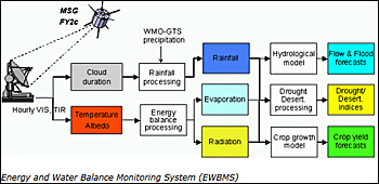
EARS will use its own developed Energy and Water Balance Monitoring System (EWBMS) that receives Meteosat visual and thermal infrared images every 15 minutes.
These are processed in near real time to hemispheric data fields of cloudiness, precipitation, temperature, radiation and evapotranspiration.
These data are subsequently used to feed a 3-dimensional rainfall- runoff forecasting system. In this way problems caused by very high or very low discharges can be anticipated and timely action can be taken.
Nine different countries
Current hydro-meteorological data collection in the Niger river basin is difficult. The basin spans 9 different countries. Data exchange is not always optimal. Measuring instrumentation is expensive in purchase and maintenance. In remote locations parts are demolished and stolen.
With the implementation of the Meteosat based system these problems are history. On the roof of the NBA office in Niamey there will be a single Meteosat receiving dish.
A computer system coupled to the receiver will process the received information daily to precipitation and actual evapotranspiration maps covering the entire region, as well as to river discharge in the various parts of the basin.
 About EWBMS
The EWBMS data collection system can be considered a major breakthrough. In large parts of the world the number of measuring stations on the ground is far from sufficient, hampering economic development.
The precipitation and evapotranspiration data are available on a 3 km grid, every day and for the entire hemisphere. The historic database covers 32 year.
It is not the first time that EARS applies its innovative satellite based technology. From 2006 to 2009 a similar system was successfully implemented in the Yellow river basin.
The Meteosat based system is not only suitable for the prediction of river discharge, but may also be used in the design of hydraulic structures. Also in the agricultural sector new challenges are addressed. Here, EARS is using its data to develop affordable drought en extreme precipitation index insurance for farmers in Africa and beyond.
Read more in the Niger river basin project: www.ears.nl/niger_basin
More information
EARS Earth Environment Monitoring
Delft, the Netherlands
+31 15 256 24 04
www.ears.nl