


Fugro's Equator detects uncharted shipwreck, still no sign of MH370
 During its search for the missing Malaysian Airlines flight MH370, Furgo's vessel Equator recently picked up a signal of debris. Closer inspection learned that it was not the missing airplane but an uncharted shipwreck.
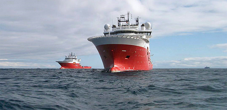
Fugro has three vessels operating for the Australian Transport Safety Bureau in search for MH370 in the southern Indian Ocean along the most likely flightpath of the Boeing aircraft.
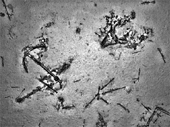 Clearly visible on the seafloor is the anchor of the discovered shipwreck.
Merchant sailing ship
The discovery was recently made at a depth of around 3.900 meters. The wreck is likely to be that of a 19th century merchant sailing ship and so great is the detail that what is believed to be scattered coal can be seen throughout the debris, which may indicate that it had an auxiliary steam-powered engine.
The debris also appears to include an anchor and the stunning imagery will be provided to expert marine archaeologists for possible identification.
"It’s a fascinating find," said the Australian Transport Safety Bureau’s (ATSB) Peter Foley, Director of the Operational Search for MH370, "but it’s not what we’re looking for. Obviously, we’re disappointed that it wasn’t the aircraft, but we were always realistic about the likelihood. And this event has really demonstrated that the systems, people and the equipment involved in the search are working well. It’s shown that if there’s a debris field in the search area, we’ll find it."
First sonar contact
When the deep tow system operated by Fugro Equator detected a cluster of small sonar contacts in the southern part of the search area, 12 nautical miles to the east of the 7th arc, the sonar data was carefully analysed. It was categorised as Class 2 – 'of potential interest but unlikely to be related to MH370'.
"It could not, however be ruled out,” said Peter Foley. "There were characteristics of the contact that made it unlikely to be MH370, but there were also aspects that generated interest, multiple small bright reflections in a relatively small area of otherwise featureless seabed."
All sonar data collected by Fugro goes through a detailed analysis and an exhaustive review process to ascertain its quality, coverage and most importantly any sonar contacts of interest.
 Fugro's Supporter was sent in for a closer inspection with the Hugin unmanned underwater vehicle.
Closer inspection with Fugro's underwater vehicle
"The analysis starts with the mission crew on board the search vessels,” continued Peter. "The data is then reviewed again ashore by sonar analysts at Fugro’s office in Perth and then it is independently reviewed by the sonar experts in the ATSB’s Operational Search team. The process is methodical, meticulous and it is designed to ensure that nothing is missed. In this case we planned to resurvey the contact in more detail."
The Fugro Supporter was tasked to further investigate the contact, performing a high resolution sonar scan using Fugro’s Echo Surveyor VII autonomous underwater vehicle (AUV).
The high resolution data revealed a large number of sonar contacts lying very close to the seafloor, at a depth of around 3,900 metres.
An additional AUV low-altitude mission was then undertaken using the underwater camera to gather images of the field. Analysis of the images revealed that the debris was actually the wreck of a ship.
Fugro’s search director Paul Kennedy of Fugro Survey explained: "This find has given us a great deal of confidence. It shows we are able to find small pieces of metal on the seafloor, a long way down. Pieces from MH370 would be roughly 10 times as big as those of the wrecked ship."
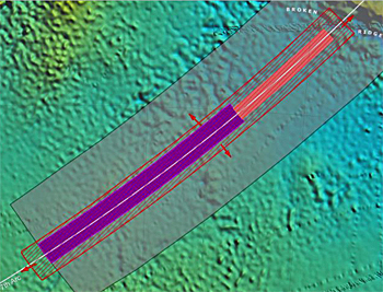 Map of the search area along the most probable flight path (white line). In purple the search area of Fugro vessels. In orange the search area of Malaysian Go Phoenix vessel. In red the extended area.
Extended search
Senior Ministers from Malaysia, Australia and the People's Republic of China recently agreed to extend the search by an additional 60,000 square kilometres to bring the search area to 120,000 square kilometres and thereby cover the entire highest probability area identified by expert analysis.
At the moment 75 percent of the initial search area has been covered.
The additional search area may take up to a year to complete given the adverse weather conditions in the approaching winter months.
This news item was originally published on the website of Fugro.
Read also on this website
● Third Fugro vessel joins search for missing flight MH370, 19 January 2015
● Fugro to conduct underwater search MH370, 7 August 2014
More information
Fugro
Leidschendam, the Netherlands
+31 70 311 1422
www.fugro.com
Impression of Fugro's deeptow survey operation.