


Expanding build-up areas on floodplains major driver for fast growing flood risks, not climate change
 Worldwide economic losses from river flooding could increase 20-fold by the end of the 21st century if no further actions on flood risk reduction are taken. Over 70 percent of this increase can be attributed to economic growth in flood prone areas.
This is the outcome of a study conducted by a Dutch research team led by dr. Hessel Winsemius from the research institute Deltares. The study was published in Nature Climate Change on 20 December.
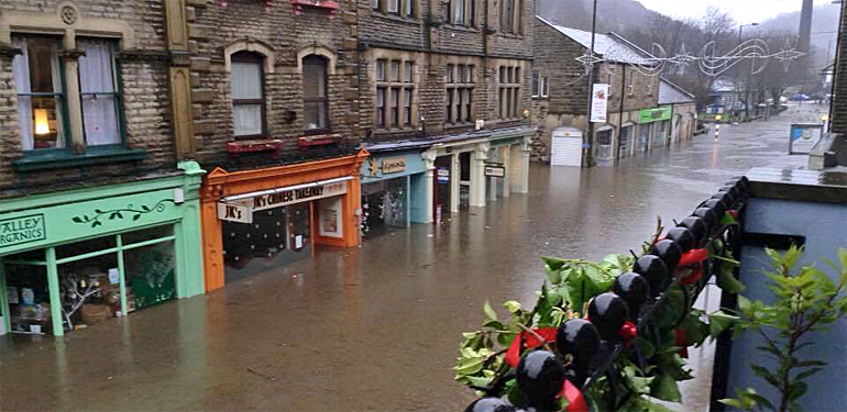
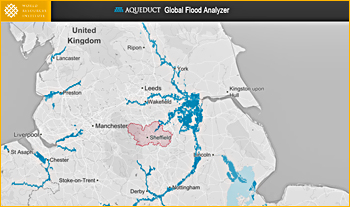 Three large river floods currently in the news (1): Ouse river, UK. In blue the river 1:10 years floodplain areas as globally mapped in Aquaduct.
Main factor: expanding build-up areas on floodplains
According to Hessel Winsemius the increase of flood risk cannot be attributed to the adverse effects of climate change alone.
The main factor that is the unlimited expansion of build-up areas in flood plains.
"Our conclusions show that besides keeping global warming well below 2 degrees Celsius target, as negotiated during the COP21 climate summit in Paris, to reduce adverse effects of climate change, a lot of future risk can be prevented by spatial planning and flood resilient building in the rapidly growing economies in flood-prone regions", says Winsemius.
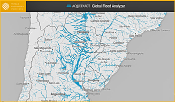 Three large river floods currently in the news (2): Paraguay river, Uruguay (global flood risk map Aquaduct)
Exposure to flood events
River flood risk is on the one hand caused by flood events, occurring with a certain frequency and severity; and on the other by the exposure of people and economy to these events.
Whilst the frequency and severity of flood events is impacted by climate change, the exposed people and economy may grow as well, resulting in more assets and economic production located in harm’s way.
The Dutch research team specifically paid attention to the fact that economic growth not only causes increase in risk, it also results in a better ability to cope with these events.
Therefore, the researchers investigated in particular where economic growth is disproportionally large in flood prone areas and how this affects risk, relative to a country’s Gross Domestic Product.
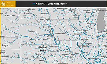 Three large river floods currently in the news (3): Missouri river, USA (global flood risk map Aquaduct)
Largest increase in South-East Asia
The patterns are different for individual world regions. Earlier studies already showed that climate change scenarios show a clear and robust signal that South East Asia will face a large increase in risk due to climate change.
This new research shows that climate change impacts are dwarfed by the effects of economic growth in flood-prone regions, and that these two drivers may compound to an increase in economic risk of a factor six in South-East Asia.
This is after correction for the economic growth in the area.
Visualisation of global river flood risks
The Dutch research team was also responsible for the tool ‘Aqueduct Global Flood Analyzer’, earlier this year. In this tool, made in collaboration with the World Resources Institute, global river flood risk (until 2030) was made visible for the general public.
Aqueduct is presently being extended with risk analysis for coastal flooding, and analysis of the feasibility and effectiveness of risk reducing measures.
Read the article 'Global drivers of future river flood risk' on the website of Nature Climate Change (not free of charge).
Go to Aquaduct Global Flood Analyzer.
This news item was originally published on the website of Deltares.
Read also on this website
● COP21: Adaptive planning for river deltas calls for flexible strategies, 10 December 2015
● WRI and four Dutch research institutes team up to develop Aqueduct flood analyzer, 1 October 2014
● Global Flood Risk Analyzer: 54 million people affected by river floods by 2030, 5 March 2015
More information
Deltares
Delft, the Netherlands
+31 88 335 8273
www.deltares.nl