


Wetlands International helps to stop downward spiral of water insecurity in Sahel region
Wetlands International and its partners working in Ethiopia, published the Atlas of the Upper Fafan catchment in north-east Ethiopia. The atlas consists of a series of vegetation cover and water resource maps over time and provides a fundamental understanding of the challenges and opportunities for conservation.
This novel approach is replicable in other catchments in disaster prone areas facing severe environmental degradation.
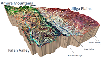 The atlas of the Upper Fafan is based on the 3D-visualization of Landsat 8 Imagery where geology and vegetation clearly stand out.
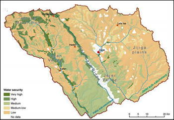
Derived from satellite data is this map on the availability of water sources with high water security (in green) in the mountain area and high insecurity (light brown) on the plains.
Fast growing population
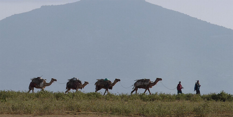
While drought puts increased constrain on the north-eastern part of Ethiopia, the root cause of the problems is that the land is overburdened with activities by a fast growing population such as intensive overgrazing by livestock and deforestation from firewood gathering.
There are no permanent sources of surface water in the area, only seasonal rivers and wetlands.
When rain falls, the barren, eroded soils cause another kind of disaster: deadly flash floods, as the land is too degraded to absorb water.
Disaster relief is crucial to save lives, but providing immediate food, aid and shelter does not address the underlying problems.
To escape the downward spiral of food and water insecurity, communities across the Sahel need to build their long-term resilience.
New approach
A critical first step in the new approach by Wetlands International was mapping the landscape, identifying the changes in landcover in time and understand how the landscape naturally provides water and restrains it.
‘An understanding of the landscape is fundamental to reverse the ongoing environmental degradation and improve livelihoods’, said Marie-Jose Vervest at Wetlands International.
‘The Upper Fafan Atlas is indispensable for guiding where and how to support long-term sustainable natural resource management in this degraded landscape.’
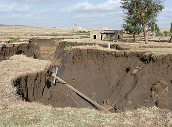 A typical phenomenon with a big impact in this part of Ethiopia is the gully erosion.
Degrading ecosystems
Rural communities in Upper Fafan catchment (3709 km2) depend heavily on natural resources for their livelihoods; hence, a lack of proper management of the environment is a serious problem.
Ecosystems are degrading at an alarming rate, mainly due to the loss of vegetation caused by overgrazing and deforestation. Extreme weather events are also increasing, and the region has suffered through years of low rainfall and a punishing drought.
The Atlas maps the landscape based on biophysical, socio-economic, land use and management, ecosystems and water resources assessments. This provides a baseline on the challenges and opportunities to halt and reverse environmental degradation using improved land and water management.
Wetlands International works in Ethiopia with its partners The Netherlands Red Cross, the Ethiopia Red Cross Society, Red Cross/Red Crescent Climate Centre and the Dutch Ministry of Foreign Affairs.
The development of the Atlas was led by Dutch consultancy firm Acacia Water.
This news item is based on articles published on the web sites of Wetlands International and Reliefweb.
Read also on this website
● Acacia Water participates in hydrogeological assessment for Darfur region, Sudan, 27 August 2017
● Degradation of wetlands in the Sahel drives massive migration to Europe, 4 May 2017
● Expertise: Water and agrifood
● Country: Ethiopia
More information
Wetlands International
Wageningen, the Netherlands
+31 318 660 910
www.wetlands.org
Acacia Water
Gouda, the Netherlands
+31 182 686 424
www.acaciawater.com
Animation showcasing integrated approaches, linking disaster risk reduction (DRR), climate change adaptation (CCA), and ecosystem management and restoration (EMR), to address the underlying problems degrading the landscape and causing disasters.