


SWWW 2018: Latest generation water-related apps for small farmers shown at African Spatial Delight
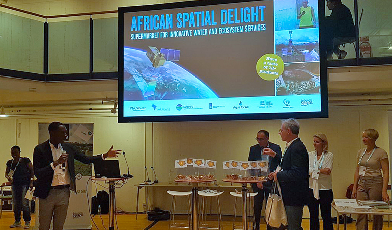
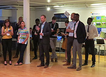
Fourteen organisations and start-ups pitched their latest versions of their geospatial data products for African farmers and citizens at the session African Spatial Delight that took place at the Stockholm World Water Week on 28 August.
The session showed the latest generation of mobile apps, using highly detailed satellite images and extended information services for the African farmers. The extended data service includes the latest market prices for their crops and the best moment to bring it to the market.
African Spacial Delight was organised by the Dutch organisations that execute the programmes Via Water, Geo-data for Agriculture and Water (G4AW) and AfriAlliance.
 Fourteen organisations and start-ups presented their geo spatial data products, using satellite data to provide African small farmers with water-related information to grow their crops.
Detailed satellite imagery
The latest versions of the water-related apps for African farmers revealed that satellite technology is developing very rapidly. New very high resolution satellites make it possible to provide small farmers with more precise water-related data of their fields.
Linked to weather information, the special developed mobile apps inform the farmers when to irrigate their crops and when it is the best time to harvest.
It also allows the farmers to better select the type of crops, to use the water more efficiency and in certain case have a second harvest.
Additional business information
The session showed that the providers of the water-related apps are expanding their information services to other areas.
In the case of the Stamp app, developed by Dutch aid organisation SNV, special geo data is provided to cattle herders (pastoralists) in the Gao district in Mali.
The herders can use the app to localize areas where there is grass for their cattle. The app has been extended with market prices for livestock and staple grains. As most herders cannot read, this information is provided via a call centre.
The project aims at a livestock productivity improvement of 10 percent, a livestock mortality reduction of 15 percent and an income from livestock sales increased by 10 percent.
Big potential
According to Ruud Grim, coordinator of the Geodata for Agriculture and Water (G4AW) programme at the Dutch National Space Office, the water-related apps have a great potential. 'In the world there are 800 million small scale farmers. Our programmes aims at 4,5 million farmers, supplying them with information so they can potentially have a second harvest’.
According to Grim, a better water management will also improve their products and eventually impacts investments.
 Senior water specialist Job Kleijn at the Dutch Ministry of Foreign Affairs suggested a global water efficiency goal on SDG6.4 for agriculture.
More water efficiency
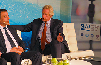
Another potential of the use of satellite-data and apps by farmers is the more efficient use of water. At a TV-recording session during the Stockholm World Water Week, senior water specialist Job Kleijn at the Dutch Ministry of Foreign Affairs linked the potential efficient water use to SDG 6.4 on water scarcity.
‘Today’s geo satellites allow us to monitor the global water use in agriculture every ten days. We can easily trace the miss use of water, providing the opportunity for national authorities to take actions’, Kleijn said.
Kleijn feels it is a missed opportunity that there is no global target for water efficiency in SDG 6.4. ‘We can use the satellite monitoring to stimulate governments to develop policies and help farmers to reduce their water use. A global target for farmers to improve their water efficiency by 25 percent on the crop they produce, is achievable’, he said.
The open database Water Productivity Database (WaPOR) of the Food and Agriculture Organization (FAO) could be an excellent tool for the monitoring of such a goal, Kleijn suggested.
Read also on this website
● Stockholm World Water Week 2018: A look back on an inspiring event to get SDG6 on track, 7 September 2018
● SWWW 2018: Blue deal seeks wisdom on water management from both sides, 6 September 2018
● SWWW 2018: Leave no one behind in WASH programmes demands a new mind-set, 3 September 2018
● SWWW 2018: Potential of blending finance remains untapped for water infrastructure in developing countries, 31 August 2018
● SWWW 2018: Water.org joins Finish Mondial to team up for affordable toilets worldwide, 31 August 2018
● SWWW 2018: Delft biotech pioneer Mark van Loosdrecht receives Stockholm Water Prize, 30 August 2018
● SWWW 2018: Open data on water availability can prevent that water scarcity leads to conflicts, 29 August 2018
● SWWW 2018: ‘Forge strong partnerships to scale up action’, 28 August 2018
● Meet the Dutch water delegation in the Netherlands pavilion at Stockholm World Water Week (booth 1 )
● Wageningen University and Rabobank help smallholder farmers worldwide to secure crop yields, 5 February 2018
● Stockholm World Water Week 2015: More crop per drop with satellites measuring water productivity, 26 August 2015
More information
Stockholm World Water Week
www.worldwaterweek.org
Via Water
The Hague, the Netherlands
+31 70 720 0870
www.viawater.nl
Geodata for Agriculture and Water (G4AW)
The Hague, the Netherlands
+31 88 042 4500
www.g4aw.spaceoffice.nl
AfriAlliance
c/o IHE-Delft
Delft, the Nehterlands
www.afrialliance.org
FAO-Wapor
www.fao.org
Video recording of the Sofa session at the Stockholm World Water Week on the use of big data for water allocation and water productivity. On the sofa are Henk Ovink (left), special Dutch water envoy, Ali Subah (middle), assistant secretary-general at the Jordanian Ministry of Water and Irrigation and Job Kleijn (right), senior officer water at the Dutch Ministry of Foreign Affairs.