


Wageningen University and Rabobank help smallholder farmers worldwide to secure crop yields
 Wageningen Environmental Research (WENR) and Rabobank have joined forces to develop a digital tool to monitor smallholders' crops.
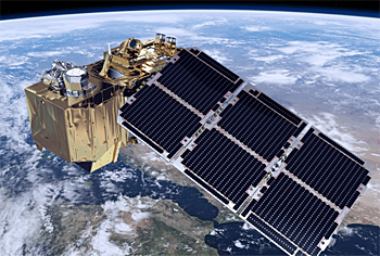
The Climate Smart Digital Farm Finance (CSDFF) tool tracks crops at field level, using images provided by the Sentinel-2 satellite. The monitoring helps lower farmers' risk profiles so that they can gain access to credit.
Farmers can use the tool to maximize their yields by adjusting irrigation and fertilizers according to the information the tool provides, and by tackling any disease or pests it detects.
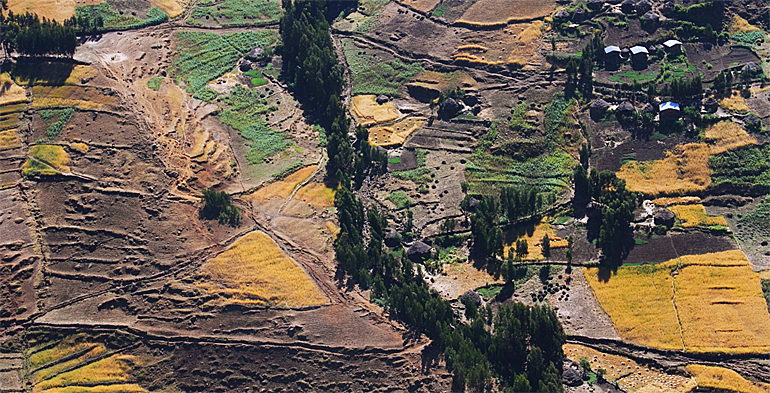
 Sentinel-2 satellite supplies regular updates on biomass development in the field.
Better credit rating
A team from WENR and Rabobank looked for actionable ways farmers could improve their credit rating.
‘We designed a so-called Green Monitor that identifies and tracks crops at field level’, says Gerbert Roerink of the Earth Informatics Team at WENR.
High resolution
‘We can achieve a resolution of 10 by 10 square meter using images from the Sentinel-2 satellite. The satellite supplies regular updates on biomass development in the field.’
A pilot project was successfully completed in December 2017, testing the tool on small barley and wheat plots in Ethiopia.
The team currently works on optimizing the model in order to implement it at a local financial institution in Ethiopia.
Lower risk profile
Access to finance is essential to boost farm productivity. However, banks are often unwilling to provide finance to farmers as they perceive it as too risky and costly.
Accurate information improves the credit assessment parameters. A more reliable risk profile could stimulate financial institutions to provide loans for smallholders, making it an important driver for economic growth and prosperity.
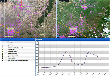 CSDFF-tool links images to the development of biomass of certain vegetation.
Reliable data for banks
‘The objective of the CSDFF tool is to provide banks with data on crop production while reducing the need to visit farms in remote areas’, adds Corné de Louw, Advisor at Rabobank International Advisory Services.
‘Regular crop monitoring, a key element in the credit cycle, has been very expensive to date, which is why it has been utilized only rarely. CSDFF makes it affordable and straightforward to implement.’
Quantify biomass development
Plants absorb the red part of sunlight and reflect the near-infra red part. Bare soil and water reflect sunlight differently.
The CSDFF tool uses this phenomenon to quantify biomass development using special vegetation indices.
The most frequently used is the Normalized Difference Vegetation Index-green. The index rates the green biomass with a number between 0 and 1, where low values (less than 0.2) represent water and bare soil, and higher values represent one or more layers of green leaves.
This news item is based on original publications on the websites of Rabobank and Wageningen University.
Read also on this website
● University of Twente supports agri network with collection of geodata in three Ethiopian watersheds, 11 December 2017
● ESA awards Blue-Value to develop space monitoring service for desert groundwater, 13 November 2017
● COP22: African agriculture gains momentum to produce more food with less water, 16 November 2016
● Deltares officially opens big data iD-Lab to assess and visualize global water issues, 29 March 2016
● Stockholm World Water Week: More crop per drop with satellites measuring water productivity, 26 August 2015
● Expertise: Water and agrifood
More information
Wageningen University
Faculty Environmental Research
Wageningen, the Netherlands
+31 317 480 700
www.wur.nl
Rabobank Development
Utrecht, the Netherlands
+31 30 216 3670
www.rabobank.com