


Drone collected data gives better insight of future development Mara wetlands, Tanzania
 Researcher Francesco Bregoli at IHE Delft has been on a three week mission to the Mara wetland, Tanzania, to gather data on the evolution of the wetland under different scenarios of climate, water use and land use changes along the whole Mara river basin. To collect the data Bregoli used a drone. The data will be used to model the evolution of the wetland and improve the management of the river and wetland.
Bregoli reported on his most recent trip to the wetlands in a blog on the website for earth and space scientists, hosted by the American Geophysical Union (AGU).
River management
In his blog Bregoli explains that when the natural equilibrium of a wetland’s ecosystem is broken by changes in water, sedimentation or nutrients feeding, the habitat morphology is altered and the ecosystem health is likely jeopardized.
Previous studies reported an increment of sediment supply to the wetland due to increasing deforestation, farming and grazing activities along the basin.
As new river structures are planned, the IHE Delft researcher expects that river management will become an important challenge for the area.
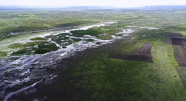
Where the Mara River leaves the Serengeti National Park, Tanzania, a meandering reach expands to form a delta and a wide wetland before flowing into Lake Victoria.
Prevent further deterioration
The wilderness of Serengeti dissolves into rural areas that envelope the swamps, but still the riverine system provides unique water resources and essential ecosystem services that should be preserved, according to Bregoli.
The measurements by Bregoli will support an analysis of the water and sediment balance within the area of the Lower Mara floodplain.
Furthermore the model will serve as a tool to improve the water resources and land use management in order to prevent the deterioration of the Mara wetland habitat and ecosystem.
High resolution
During the mission Bregoli deployed UAV flights to observe areas otherwise unattainable from the ground and to represent the wetland morphology features at high resolution.
For the measurement of water discharges he used an ADCP in several key channels of the network, cruised the wetland to map the bed topography with a sonar and gathered suspended sediments samples.
Bregoli also reports on the talks he had with people of the local communities and he noticed a number of ongoing human activities that might modify the environment and particularly the river network, such as the burning of riparian vegetation to create new croplands and to provide fisherman access to the river, livestock paths and wades as well as banks opening for land irrigation.
These are among the reasons of natural levees destruction and therefore river bifurcation or deviation.
Read Bregoli's original blog on the AGU-website.
On 2 February World Wetlands Day is celebrated to raise awareness about the value of wetlands for humanity and the planet. This year's theme is 'Wetlands for an sustainable urban future'.
Read also on this website
● IGRAC and IHE Delft organise groundwater governance training in Benin, 4 December 2017
● Stockholm World Water Week 2017: IHE Delft to assess water management needs in Iraq, 30 August 2017
● A4Lab deploys drones to explore water potential of dry river beds in Mozambique, 21 May 2017
● Expertise: Enabling delta life
● Country: Tanzania
More information
IHE Delft
Delft, the Netherlands
+31 15 215 23 21
www.un-ihe.org