


Prof Marc Bierkens: world is using 3.5 times more groundwater than it has
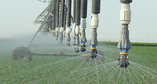
At the global level, people are using 3.5 times more groundwater than is available. Particularly in Northern America and Asia, groundwater depletion in the major agricultural areas is such that 1.7 billion people find themselves under threat.
This has been shown by a new method developed by Utrecht University and the McGill University in Canada. In the Netherlands, the study was lead by Marc Bierkens, the Professor of Hydrology at Utrecht University who also works for Deltares.
Publication in Nature
The study also drew on Deltares software and data. The results were published recently in the authoritative scientific journal Nature in an article entitled 'Water balance of global aquifers revealed by groundwater footprint'.
Balance between use and renewal
The researchers developed a method for stating the balance between groundwater use and renewal in a given area: the 'groundwater footprint'. It can be used globally region by region to see whether groundwater is being used sustainably or whether the resource is being depleted.
Major agricultural areas being depleted
Marc Bierkens: "The groundwater footprint is the surface area needed to establish a balance between groundwater extraction in an area and replenishment by rainwater, while maintaining an adequate river flow to preserve the viability of ecosystems. When the groundwater footprint exceeds one, extraction has reached an unsustainable level and that means that the groundwater resources are being depleted. We found that the groundwater resources in 20 per cent of the major agricultural areas are being depleted to such an extent that 1.7 billion people are under threat. These are mainly areas in Northern America and Asia."
Taking better decisions
Utrecht University has, together with Deltares, been studying groundwater use for many years. Marc Bierkens believes that the chief benefit of this study is that the problem is presented in a clear way, making it possible to take better decisions about how land is used.
Better groundwater management
Bierkens: "The groundwater footprint clearly identifies regional differences in sustainable groundwater use. As a result, policymakers and government authorities can see where agriculture is depleting the groundwater and where groundwater can still be used to enhance agricultural production. That opens the door to better groundwater management."
World map groundwater footprint
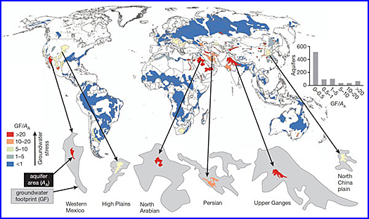
The dark-blue areas have a groundwater footprint of less than 1; groundwater extraction is sustainable here in the long term as well. However, the red areas in Northern America and Asia have a much larger groundwater footprint. The footprint of the Upper Ganges is actually 54 times larger. The area would have to be 54 times larger to capture the precipitation needed to sustain current groundwater extraction. Groundwater in areas with a large groundwater footprint is severely depleted. The bar chart shows that the groundwater footprint is less than 1 for most areas (80%). The groundwater is being used sustainably here.
This news item was originally published on the website of Deltares.
More information
Deltares
Delft, the Netherlands
+31 88 335 8273
www.deltares.nl
University of Utrecht
Marc Bierkens
Utrecht, the Netherlands