


World Water Forum 8: World Water Atlas gathers compelling stories on urgent water issues
The online World Water Atlas had its global debut in the Netherlands Pavilion at the World Water Forum 8 in Basilia, Basil. The atlas is meant to share lessons learned and good practises on water issues from all over the world.
By publishing compelling stories on the three topics, how to tackle too much, too little, and too dirty water, the initiators want to draw attention to solutions that have proven themselves in practise and have the potential of scaling worldwide.
The founding partners of the World Water Atlas are the Kingdom of the Netherlands, Deltares, the Netherlands Environmental Assessment Agency and the International Architecture Biennale Rotterdam, with support from the Dutch water sector and under the patronage of the UN/World Bank High Level Panel on Water.
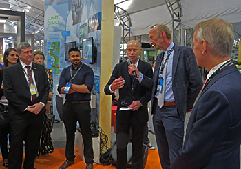 Presentation of the World Water Atlas in the Netherlands Pavilion at the World Water Forum 8, attended by Dutch special water envoy Henk Ovink (middle).
First powerful stories
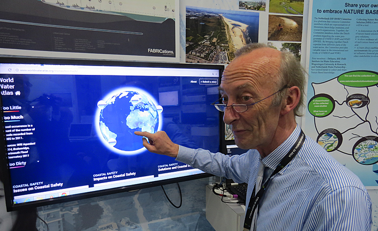
Cees van de Guchte (on top photo) of research institute Deltares, who coordinates the development process, demonstrated the atlas in the Netherlands pavilion. The debut of the online platform at the World Water Forum marked just the start of the platform.
By touching the screen, Van de Guchte showed the first stories that have now been entered. So far eight organisations, including the International Water Association and KWR City Blueprint, shared their stories.
The World Water Atlas will also deliver short documentary films, hardcopy outreach and public presentations and debates.
More stories to share
‘The atlas now only shows the first stories, but we need lots more’, Van de Guchte raised at the platform’s debute in Brasil. ‘We invite everybody to share their experiences with good workable solutions. Everybody is free to send in a story on a good or bad experiences.’
The website has a formula to send in proposals. Van de Guchte called for stories on very concrete cases of solutions that have a perspective to be used on other locations as well.
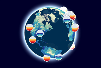 At the hearth of the World Water Atlas is a rotating globe with icons on the location of the stories that are told on too much water (in blue), too little water (in yellow) and too dirty water (in purple).
Presentation on World Water Day
Two days later, on World Water Day, the atlas was officially presented in New York to the United Nations and the World Bank. The presentation was made by Dutch special water envoy Henk Ovink who took the initiative to develop this platform for compelling narratives and action.
The platform is endorsed by the High Level Platform that pointed out that the world needs to understand the risks of water and that these risks need to be link to potential solutions to inspire action.
Earlier in March, Prime minister Mark Rutte of the Netherlands, when meeting with the Sherpas of the UN and World Bank’s High Level Panel on Water, confirmed the urgency and need for action to better understand and address these complex risks.
He expressed the need of many politicians around the world: ‘Give me a powerful story I can work with’.
This news item was originally published on the website of Deltares.
Read also on this website
● World Water Forum 8: A look back on a Forum under pressure to achieve SDG6 by 2030, 29 March 2018
● World Water Forum 8: Huge potential for nature based solutions to reduce water risks, 28 March 2018
● World Water Forum 8: Revitalised IWRM-concept can boost action on SDG6 for water, 27 March 2018
● World Water Forum 8: Launch of Dutch Blue Deal programme in support of SDG6 on water, 23 March 2018
● World Water Forum 8: Water Youth Network strengthens ties with research institute Deltares, 21 March 2018
● World Water Forum 8: A call on the world to fully value water, not just prizing, 21 March 2018
● World Water Forum 8: Thirsty cities need to double investments in water infrastructure, 20 March 2018
● Special page on Dutch participation at World Water Forum 8
More information
World Water Atlas
www.worldwateratlas.org